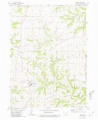
1980 Map of Andrew
USGS Topo · Published 1981About this map
The town of Andrew sits at the convergence of several rural townships in eastern Iowa, serving as a central hub for the surrounding agricultural landscape. During the late 1970s, the area maintained its traditional rural character, anchored by small settlements like Cottonville and the local church grounds at St Johns Cem. The terrain is defined by a dense network of drainages including Brush Creek, Jess Branch, and Cedar Creek, which carve through the countryside and influence the placement of farms and roads. Evidence of local industry and infrastructure is visible through a scattered Quarry and the Sewage Disposal Ponds near the primary town site. This map provides a clear view of the intersection between Richland, Bellevue, Perry, and Jackson townships, offering genealogists a precise look at the land and cemeteries such as the County Cem and a lonely Grave site as they existed forty years ago.
Find a feature on this map
14 named features on this map. Tap any name to fly to it.
Don’t see what you’re looking for? This feature index may not catch every label — zoom into the map to look around manually.
Map Details
Editions of this 1980 Andrew Map
This is the sole edition of this map. No revisions or reprints were ever made.
Other maps of this area

1891 · Maquoketa
USGS Topo · 1:62,500

1901 · Peosta
USGS Topo · 1:125,000

1911 · Galena
USGS Topo · 1:62,500

1913 · Galena
USGS Topo · 1:62,500

1935 · East Dubuque
USGS Topo · 1:62,500

1935 · Miles
USGS Topo · 1:62,500

1940 · East Dubuque
USGS Topo · 1:62,500

1941 · Miles
USGS Topo · 1:62,500

1959 · Dubuque
USGS Topo · 1:250,000

1961 · Dubuque
USGS Topo · 1:250,000