
1941 Map of Miles
USGS Topo · Published 1941About this map
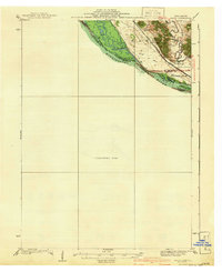
The Mississippi River corridor dominates this 1930s-era survey, revealing a landscape of intricate waterways and braided islands along the Illinois and Iowa border. Significant topographic detail is concentrated in the northeast corner, where the Apple River cuts through the bluffs near the settlement of Whitton. This area serves as a focal point for local transportation and community life, anchored by the Chicago Burlington and Quincy railroad line that tracks the river's eastern bank.
Find a feature on this map
18 named features on this map. Tap any name to fly to it.
Don’t see what you’re looking for? This feature index may not catch every label — zoom into the map to look around manually.
Map Details
Editions of this 1941 Miles Map
2 editions found
Other maps of this area

1891 · DeWitt
USGS Topo · 1:62,500

1891 · Maquoketa
USGS Topo · 1:62,500

1891 · Clinton
USGS Topo · 1:62,500

1892 · Goose Lake
USGS Topo · 1:62,500

1892 · Savanna
USGS Topo · 1:62,500

1894 · Goose Lake
USGS Topo · 1:62,500

1894 · Clinton
USGS Topo · 1:62,500

1899 · Clinton
USGS Topo · 1:125,000

1901 · Peosta
USGS Topo · 1:125,000

1901 · Rock Island
USGS Topo · 1:125,000