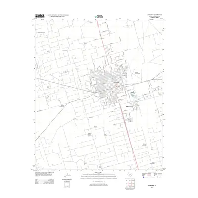
2012 Map of Andrews
USGS Topo · Published 2012About this map
Andrews serves as the focal point of this West Texas landscape, showing a dense street grid that transitions into the outlying residential area of McKinney Acres. The region's industrial character is defined by a sprawling network of energy infrastructure, including the Andrews North Oil Field, Andrews Oil Field, and Parker Oil Field. Beyond the town center, the terrain is dotted with numerous named windmills such as Evans Windmill, Allen Windmill, and Rhodes Windmill, alongside the Adobe Ranch. These features suggest a landscape where ranching traditions and modern petroleum extraction coexist. Significant transportation and commerce hubs are noted, most notably the Andrews County Airport, which provides a vital link for this oil-rich county seat. The map also records a systematic numbering of windmills across the plains, from Windmill Number Two to Windmill Number Twelve, illustrating the organized management of water resources in this arid environment.
Find a feature on this map
130 named features on this map. Tap any name to fly to it.
Don’t see what you’re looking for? This feature index may not catch every label — zoom into the map to look around manually.
Map Details
Editions of this 2012 Andrews Map
This is the sole edition of this map. No revisions or reprints were ever made.
Other maps of this area

1954 · Hobbs
USGS Topo · 1:250,000

1958 · Hobbs
USGS Topo · 1:250,000

1963 · Andrews
USGS Topo · 1:24,000

1968 · North Cowden NW
USGS Topo · 1:24,000

1968 · Gardendale NW
USGS Topo · 1:24,000

1968 · Clabber Hill Ranch
USGS Topo · 1:24,000

1971 · Five Wells Ranch NW
USGS Topo · 1:24,000

1971 · Florey
USGS Topo · 1:24,000
1971 · Five Wells Ranch SW
USGS Topo · 1:24,000

1971 · Shafter Lake
USGS Topo · 1:24,000