
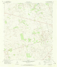
1968 Map of North Cowden NW
USGS Topo · Published 1970About this map
The Fuhrman Mascho Oil Field dominates this West Texas landscape, showing the intensive infrastructure of the Permian Basin's mid-century energy production. Surveyed in the late 1960s, the terrain is defined more by industrial development than by natural features, with a dense network of unimproved roads and several Pipelines cutting across the desert. The presence of the Embar Oil Field to the southwest and the Emma Oil Field in the southeast corner further highlights the regional importance of petroleum extraction during this era. Small industrial excavations, such as a scattered Gravel Pit, provided the raw materials for the access roads and pads required to maintain these sprawling fields. The map captures the specialized spatial layout of a landscape dedicated almost entirely to resource recovery, where survey lines and service routes outnumber topographical landmarks.
Find a feature on this map
5 named features on this map. Tap any name to fly to it.
Don’t see what you’re looking for? This feature index may not catch every label — zoom into the map to look around manually.
Map Details
Editions of this 1968 North Cowden NW Map
This is the sole edition of this map. No revisions or reprints were ever made.
Other maps of this area

1954 · Hobbs
USGS Topo · 1:250,000

1958 · Hobbs
USGS Topo · 1:250,000

1963 · Andrews
USGS Topo · 1:24,000

1967 · North Cowden
USGS Topo · 1:24,000

1968 · Coyote Corner
USGS Topo · 1:24,000

1968 · Clabber Hill Ranch
USGS Topo · 1:24,000

1971 · Whalen Lake
USGS Topo · 1:24,000

1971 · Bedford Ranch
USGS Topo · 1:24,000

1971 · Sand Ranch
USGS Topo · 1:24,000
1971 · Lazy X Ranch
USGS Topo · 1:24,000