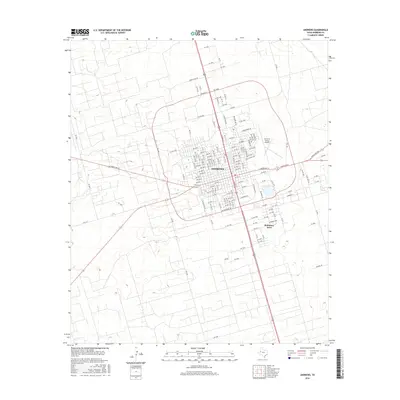
2016 Map of Andrews
USGS Topo · Published 2016About this map
The high plains of the Permian Basin define this 2016 survey, centered on the growing community of Andrews. The town's grid is dense with residential and commercial thoroughfares, including E Broadway St and Commerce Dr, reflecting its status as a regional hub. To the north, the landscape transitions toward larger tracts along Green Acres Rd, while the Andrews County Airport serves the area's transportation needs. Just south of the main municipal center lies the residential development of McKinney Acres, situated near Taylor St. The transport network is anchored by several state-maintained routes, most notably Ranch Rd 87 and Ranch Rd 703, which connect the town to the surrounding agricultural and industrial lands of West Texas.
Find a feature on this map
14 named features on this map. Tap any name to fly to it.
Don’t see what you’re looking for? This feature index may not catch every label — zoom into the map to look around manually.
Map Details
Editions of this 2016 Andrews Map
This is the sole edition of this map. No revisions or reprints were ever made.
Other maps of this area

1954 · Hobbs
USGS Topo · 1:250,000

1958 · Hobbs
USGS Topo · 1:250,000

1963 · Andrews
USGS Topo · 1:24,000

1968 · North Cowden NW
USGS Topo · 1:24,000

1968 · Gardendale NW
USGS Topo · 1:24,000

1968 · Clabber Hill Ranch
USGS Topo · 1:24,000

1971 · Five Wells Ranch NW
USGS Topo · 1:24,000

1971 · Florey
USGS Topo · 1:24,000
1971 · Five Wells Ranch SW
USGS Topo · 1:24,000

1971 · Shafter Lake
USGS Topo · 1:24,000