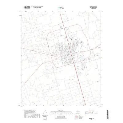
2019 Map of Andrews
USGS Topo · Published 2019About this map
The West Texas city of Andrews sits at the heart of this survey, serving as the primary hub for the surrounding Permian Basin landscape. A distinct radial road network anchors the settlement, with Ranch Rd 87 and local routes like SW 1001 stretching out into the arid plains. To the southeast, the residential cluster of McKinney Acres represents modern expansion along the city’s periphery near Taylor St.
Find a feature on this map
163 named features on this map. Tap any name to fly to it.
Don’t see what you’re looking for? This feature index may not catch every label — zoom into the map to look around manually.
Map Details
Editions of this 2019 Andrews Map
This is the sole edition of this map. No revisions or reprints were ever made.
Other maps of this area

1954 · Hobbs
USGS Topo · 1:250,000

1958 · Hobbs
USGS Topo · 1:250,000

1963 · Andrews
USGS Topo · 1:24,000

1968 · North Cowden NW
USGS Topo · 1:24,000

1968 · Gardendale NW
USGS Topo · 1:24,000

1968 · Clabber Hill Ranch
USGS Topo · 1:24,000

1971 · Five Wells Ranch NW
USGS Topo · 1:24,000

1971 · Florey
USGS Topo · 1:24,000
1971 · Five Wells Ranch SW
USGS Topo · 1:24,000

1971 · Shafter Lake
USGS Topo · 1:24,000