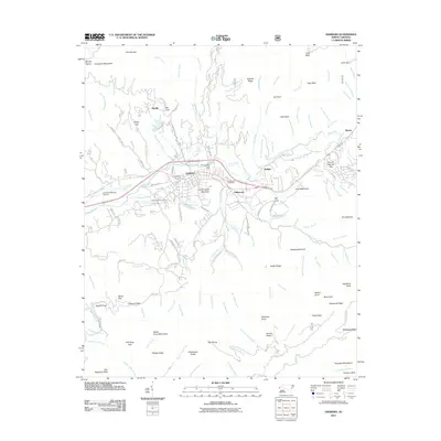
2011 Map of Andrews
USGS Topo · Published 2011About this map
The Valley River flows through the heart of this Appalachian landscape, anchoring a corridor of settlement that includes Andrews, Valleytown, and Buffalo. The terrain is defined by the Snowbird Mountains to the north and the Valley River Mountains to the south, creating a constrained valley where transportation and industry are concentrated. Notable landmarks include the Andrews-Murphy Airport and the Georgia State Prison Camp, while numerous smaller coves like John West Cove and Ash Cove suggest the tucked-away nature of residential life in these foothills. Genealogists will find the Valleytown Cemetery and Valley River Cemetery centrally located near the primary settlements. The map also records a dense network of mountain hydrology, from Worm Creek to the Spread Eagle Branch, highlighting the numerous water sources that have historically shaped the agricultural and timber patterns of Cherokee County.
Find a feature on this map
162 named features on this map. Tap any name to fly to it.
Don’t see what you’re looking for? This feature index may not catch every label — zoom into the map to look around manually.
Map Details
Editions of this 2011 Andrews Map
This is the sole edition of this map. No revisions or reprints were ever made.
Other maps of this area

1933 · Bushnell
USGS Topo · 1:62,500

1935 · Peachtree
USGS Topo · 1:24,000

1935 · Robbinsville
USGS Topo · 1:24,000

1935 · Shooting Creek
USGS Topo · 1:24,000

1935 · Topton
USGS Topo · 1:24,000

1935 · Marble
USGS Topo · 1:24,000

1935 · Wayah Bald
USGS Topo · 1:48,000

1935 · Santeetlah Creek
USGS Topo · 1:24,000

1935 · Andrews
USGS Topo · 1:24,000
1935 · Hayesville
USGS Topo · 1:24,000