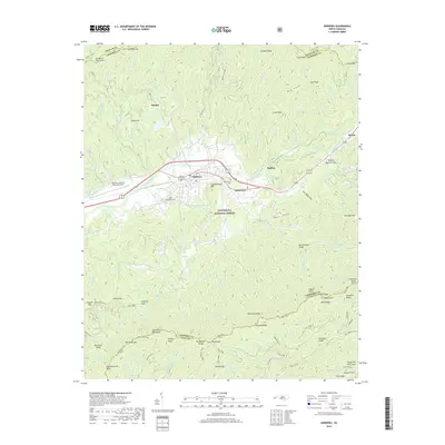
2019 Map of Andrews
USGS Topo · Published 2019About this map
The town of Andrews serves as a central hub in this valley landscape, bordered by the Snowbird Mountains to the north and the Tusquitee Mountains to the south. Much of the surrounding high ground is protected within the Nantahala National Forest, where the terrain is marked by steep ridges like Stewart Ridge and Sassafas Ridge. This modern topographic survey illustrates the development of the valley floor, showing the infrastructure of the Western Carolina Regional Airport and the residential clusters at Valleytown and Buffalo.
Find a feature on this map
147 named features on this map. Tap any name to fly to it.
Don’t see what you’re looking for? This feature index may not catch every label — zoom into the map to look around manually.
Map Details
Editions of this 2019 Andrews Map
This is the sole edition of this map. No revisions or reprints were ever made.
Other maps of this area

1933 · Bushnell
USGS Topo · 1:62,500

1935 · Peachtree
USGS Topo · 1:24,000

1935 · Robbinsville
USGS Topo · 1:24,000

1935 · Shooting Creek
USGS Topo · 1:24,000

1935 · Topton
USGS Topo · 1:24,000

1935 · Marble
USGS Topo · 1:24,000

1935 · Wayah Bald
USGS Topo · 1:48,000

1935 · Santeetlah Creek
USGS Topo · 1:24,000

1935 · Andrews
USGS Topo · 1:24,000
1935 · Hayesville
USGS Topo · 1:24,000