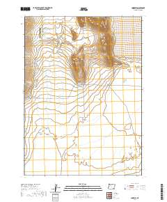
2020 Map of Andrews
USGS Topo · Published 2020About this map
Andrews sits at the base of the high desert terrain in this section of southeastern Oregon, serving as a focal point for the surrounding Wildhorse Valley. This 2020 update documents the remote landscape where water is a precious commodity, marked by features such as Serrano Spring, Dixon Spring, and the artificial Kueny Ditch. The settlement is closely tied to its ranching heritage, evidenced by Kueny Ranch Ln and the Wildhorse Valley Airport. To the east, the terrain transitions into the stark expanse of the Alvord Desert and the ephemeral Alvord Lake, illustrating the Great Basin geography of the region. Local history and genealogy are anchored by the Andrews Cem located along Penland Rd, while the primary transit routes of E Steens Rd and Fields-Denio Rd connect this isolated outpost to the wider county.
Find a feature on this map
27 named features on this map. Tap any name to fly to it.
Don’t see what you’re looking for? This feature index may not catch every label — zoom into the map to look around manually.
Map Details
Editions of this 2020 Andrews Map
This is the sole edition of this map. No revisions or reprints were ever made.
Other maps of this area

1955 · Adel
USGS Topo · 1:250,000

1957 · Adel
USGS Topo · 1:250,000

1958 · Adel
USGS Topo · 1:250,000

1962 · Adel
USGS Topo · 1:250,000

1968 · Alvord Hot Springs
USGS Topo · 1:24,000

1968 · Ankle Creek
USGS Topo · 1:24,000

1971 · Andrews
USGS Topo · 1:24,000

1971 · V Lake
USGS Topo · 1:24,000

1971 · Fields
USGS Topo · 1:24,000

1971 · Borax Lake
USGS Topo · 1:24,000