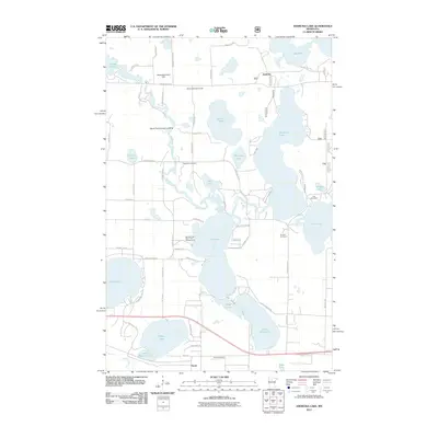
2011 Map of Andrusia Lake
USGS Topo · Published 2011About this map
Andrusia Lake and its surrounding water bodies dominate this portion of the northern Minnesota lake country, illustrating a landscape defined by the winding course of the Mississippi River. The river connects a chain of lakes including Stump Lake, Wolf Lake, and Cass Lake, regulated in part by the Mississippi River Dam. This 2011 survey captures the area's dual character as a recreational destination and a settled rural community. Established landmarks like the Big Wolf Lake Resort and Campground, Mo-Kah-Um Camp, and the Greenwood Golf Course signify the importance of tourism. Meanwhile, the presence of the East Side Cemetery and Farris Cemetery near the settlement of Farris provides critical data points for genealogists tracking family history in the township.
Find a feature on this map
70 named features on this map. Tap any name to fly to it.
Don’t see what you’re looking for? This feature index may not catch every label — zoom into the map to look around manually.
Map Details
Editions of this 2011 Andrusia Lake Map
This is the sole edition of this map. No revisions or reprints were ever made.
Other maps of this area

1920 · Buena Vista
USGS Topo · 1:62,500

1954 · Bemidji
USGS Topo · 1:250,000

1957 · Bemidji
USGS Topo · 1:250,000

1958 · Bemidji
USGS Topo · 1:250,000

1968 · Guthrie
USGS Topo · 1:24,000

1968 · Bemidji East
USGS Topo · 1:24,000

1972 · Turtle River Lake
USGS Topo · 1:24,000
1972 · Pimushe Lake
USGS Topo · 1:24,000

1972 · Pike Bay
USGS Topo · 1:24,000
1972 · Turtle River
USGS Topo · 1:24,000