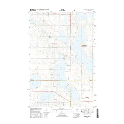
2016 Map of Andrusia Lake
USGS Topo · Published 2016About this map
The Mississippi River winds through this lake-heavy corridor of the Chippewa National Forest, connecting the expansive Andrusia Lake and Wolf Lake. The settlement of Farris sits near the southern edge of the map, serving as a landmark for local history and genealogy alongside the nearby Farris Cem and East Side Cem. This area is defined by its complex hydrology, where the Necktie River feeds into Little Midge Lake and Midge Lake, while the western reaches of Cass Lake and Allens Bay dominate the eastern border. The road network, including Co Hwy 33 and numerous forest service roads like Wagon Wheel Dr SE, reveals the modern access points to these water bodies. Cultural and recreational sites like the Island Point Canoe Landing underscore the long-standing importance of these waterways as a primary navigation and transit network through the Minnesota woods.
Find a feature on this map
107 named features on this map. Tap any name to fly to it.
Don’t see what you’re looking for? This feature index may not catch every label — zoom into the map to look around manually.
Map Details
Editions of this 2016 Andrusia Lake Map
This is the sole edition of this map. No revisions or reprints were ever made.
Other maps of this area

1920 · Buena Vista
USGS Topo · 1:62,500

1954 · Bemidji
USGS Topo · 1:250,000

1957 · Bemidji
USGS Topo · 1:250,000

1958 · Bemidji
USGS Topo · 1:250,000

1968 · Guthrie
USGS Topo · 1:24,000

1968 · Bemidji East
USGS Topo · 1:24,000

1972 · Turtle River Lake
USGS Topo · 1:24,000
1972 · Pimushe Lake
USGS Topo · 1:24,000

1972 · Pike Bay
USGS Topo · 1:24,000
1972 · Turtle River
USGS Topo · 1:24,000