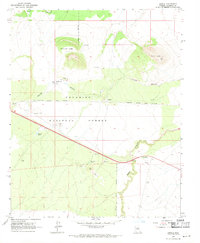
1968 Map of Angell
USGS Topo · Published 1971About this map
Angell is positioned as a key stop along the Atchison Topeka and Santa Fe railway, serving as a focal point for this high-desert landscape in northern Arizona. The area is defined by its volcanic geology and transit history, where the Twin Arrows Trading Post sits near the alignment of Route 66 and the modern Interstate 40. The terrain is marked by distinctive geological features like Rattlesnake Crater and Merrill Crater, alongside the deep incisions of Youngs Canyon and Padre Canyon. Historical human presence is etched into the land, from ancient Petroglyphs and scattered Ruins to the more recent cattle operations at Walking Cane Ranch. This environment necessitated extensive water management, as evidenced by several named reservoirs such as Colcord Tank and Padre Tank. Local industry is represented by numerous extraction sites, including a Cinder Pit and Borrow Pit, which supported the region's infrastructure and railroad maintenance.
Find a feature on this map
24 named features on this map. Tap any name to fly to it.
Don’t see what you’re looking for? This feature index may not catch every label — zoom into the map to look around manually.
Map Details
Editions of this 1968 Angell Map
3 editions found
Other maps of this area

1886 · San Francisco Mtns
USGS Topo · 1:250,000

1891 · San Francisco Mtns
USGS Topo · 1:250,000

1894 · San Francisco Mtns
USGS Topo · 1:250,000

1899 · San Francisco Mtns
USGS Topo · 1:250,000

1947 · Flagstaff
USGS Topo · 1:250,000

1954 · Flagstaff
USGS Topo · 1:250,000

1958 · Flagstaff
USGS Topo · 1:250,000

1960 · Flagstaff
USGS Topo · 1:250,000

1962 · Flagstaff
USGS Topo · 1:250,000
1962 · Ashurst Lake
USGS Topo · 1:24,000