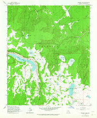
1962 Map of Ashurst Lake
USGS Topo · Published 1964About this map
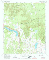
Coconino National Forest encompasses this high-altitude landscape, dominated by a series of natural basins and reservoirs that sustain the region's ecology. Upper Lake Mary stretches across the western edge of the sheet, providing a significant contrast to the ephemeral water bodies like Horse Lake and Camel Francis Lake found further east. The presence of Ashurst Lake at the southeastern corner, supported by the Coconino Dam, highlights the area's importance for water management and recreation during the mid-20th century.
Find a feature on this map
43 named features on this map. Tap any name to fly to it.
Don’t see what you’re looking for? This feature index may not catch every label — zoom into the map to look around manually.
Map Details
Editions of this 1962 Ashurst Lake Map
5 editions found
Other maps of this area

1886 · San Francisco Mtns
USGS Topo · 1:250,000

1887 · Verde
USGS Topo · 1:250,000

1891 · San Francisco Mtns
USGS Topo · 1:250,000

1892 · Verde
USGS Topo · 1:250,000

1894 · San Francisco Mtns
USGS Topo · 1:250,000

1899 · San Francisco Mtns
USGS Topo · 1:250,000

1908 · Flagstaff
USGS Topo · 1:125,000

1912 · Flagstaff
USGS Topo · 1:125,000

1923 · Camp Verde
USGS Topo · 1:125,000

1932 · Camp Verde
USGS Topo · 1:125,000