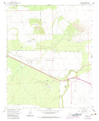
1968 Map of Angell
USGS Topo · Published 1983About this map
The high desert of the Coconino National Forest is defined here by ancient volcanic geology and the arteries of 20th-century travel. Dominating the northern landscape are the prominent rims of Rattlesnake Crater and Merrill Crater, while deeper human history is recorded in nearby Petroglyphs and scattered Ruins. These ancient markers stand in contrast to the industrial footprint of the Atchison Topeka and Santa Fe railroad, which parallels the path of the old Route 66 corridor.
Find a feature on this map
24 named features on this map. Tap any name to fly to it.
Don’t see what you’re looking for? This feature index may not catch every label — zoom into the map to look around manually.
Map Details
Editions of this 1968 Angell Map
3 editions found
Other maps of this area

1886 · San Francisco Mtns
USGS Topo · 1:250,000

1891 · San Francisco Mtns
USGS Topo · 1:250,000

1894 · San Francisco Mtns
USGS Topo · 1:250,000

1899 · San Francisco Mtns
USGS Topo · 1:250,000

1947 · Flagstaff
USGS Topo · 1:250,000

1954 · Flagstaff
USGS Topo · 1:250,000

1958 · Flagstaff
USGS Topo · 1:250,000

1960 · Flagstaff
USGS Topo · 1:250,000

1962 · Flagstaff
USGS Topo · 1:250,000
1962 · Ashurst Lake
USGS Topo · 1:24,000