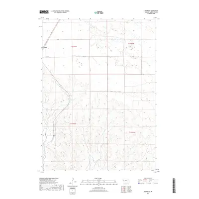
2017 Map of Angora SE
USGS Topo · Published 2017About this map
Angora and the small settlement of Vance anchor the landscape of northern Morrill County, where the High Plains terrain is shaped by an intricate network of drainages and man-made irrigation infrastructure. The passage of Indian Cr and Upper Dugout Cr through the southern sections reveals a deeply eroded topography that contrasts with the flatter tablelands to the north. A significant marker of the region’s agricultural development is the Northport Canal, which cuts through the southwestern corner, reflecting the vital role of water management in this part of Nebraska. The map details a systematic grid of rural transit including RD 120 and Co RD 101, which connect isolated homesteads and ranching tracts within the township divisions of t21n r50w and t22n r49w.
Find a feature on this map
18 named features on this map. Tap any name to fly to it.
Don’t see what you’re looking for? This feature index may not catch every label — zoom into the map to look around manually.
Map Details
Editions of this 2017 Angora SE Map
This is the sole edition of this map. No revisions or reprints were ever made.
Other maps of this area

1896 · Browns Creek
USGS Topo · 1:125,000

1898 · Camp Clarke
USGS Topo · 1:125,000

1899 · Browns Creek
USGS Topo · 1:125,000

1949 · Lynn
USGS Topo · 1:62,500

1954 · Scottsbluff
USGS Topo · 1:250,000

1958 · Scottsbluff
USGS Topo · 1:250,000

1965 · Bridgeport NW
USGS Topo · 1:24,000

1965 · Angora SE
USGS Topo · 1:24,000

1965 · Broadwater NW
USGS Topo · 1:24,000
1965 · Angora NE
USGS Topo · 1:24,000