
1965 Map of Broadwater NW
USGS Topo · Published 1967About this map
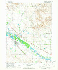
North Platte River waters dominate the southern edge of this landscape, where the Union Pacific railroad tracks parallel the riverbank in Morrill County. The mid-1960s terrain is defined by an extensive system of irrigation works, including the Northport Canal and Browns Creek Canal, which carve through the plains to support local agriculture. The map reveals a rural social structure anchored by small landmarks such as Rocky Ridge Sch and Kelly Sch, providing specific points of interest for genealogists tracing family roots in the Nebraska Panhandle.
Find a feature on this map
15 named features on this map. Tap any name to fly to it.
Don’t see what you’re looking for? This feature index may not catch every label — zoom into the map to look around manually.
Map Details
Editions of this 1965 Broadwater NW Map
This is the sole edition of this map. No revisions or reprints were ever made.
Other maps of this area

1896 · Browns Creek
USGS Topo · 1:125,000

1898 · Camp Clarke
USGS Topo · 1:125,000

1899 · Browns Creek
USGS Topo · 1:125,000

1949 · Lynn
USGS Topo · 1:62,500

1954 · Scottsbluff
USGS Topo · 1:250,000

1958 · Scottsbluff
USGS Topo · 1:250,000

1965 · Broadwater
USGS Topo · 1:24,000

1965 · Angora SE
USGS Topo · 1:24,000

1965 · Courthouse Rock
USGS Topo · 1:24,000
1965 · Bridgeport
USGS Topo · 1:24,000