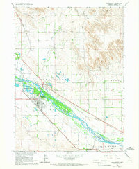
1965 Map of Bridgeport
USGS Topo · Published 1967About this map
The North Platte River serves as the geographic heart of this mid-1960s study, its braided channels and adjacent Browns Creek Channel defining the local hydrology. The city of Bridgeport occupies a strategic position south of the river, anchored by a grid of streets and significant infrastructure like the Substation and Fairground. To the north, Northport sits at the junction of two major western railroads, the Chicago Burlington and Quincy and the Union Pacific. Evidence of the region's pioneering history is present in the Emigrant Trail crossing the southern terrain near Court House Rock. The landscape is heavily shaped by irrigation and water management, visible through the extensive network of the Northport Canal, Belmont Canal, and Meredith Ammer Canal that support the agricultural parcels surrounding the river valley.
Find a feature on this map
39 named features on this map. Tap any name to fly to it.
Don’t see what you’re looking for? This feature index may not catch every label — zoom into the map to look around manually.
Map Details
Editions of this 1965 Bridgeport Map
2 editions found
Other maps of this area

1896 · Browns Creek
USGS Topo · 1:125,000

1898 · Camp Clarke
USGS Topo · 1:125,000

1899 · Browns Creek
USGS Topo · 1:125,000

1949 · Lynn
USGS Topo · 1:62,500

1954 · Scottsbluff
USGS Topo · 1:250,000

1958 · Scottsbluff
USGS Topo · 1:250,000

1965 · Bridgeport NW
USGS Topo · 1:24,000

1965 · Angora SE
USGS Topo · 1:24,000

1965 · Courthouse Rock
USGS Topo · 1:24,000

1965 · Broadwater NW
USGS Topo · 1:24,000