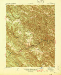
1944 Map of Annapolis
USGS Topo · Published 1944About this map
The northern reaches of Sonoma County are defined by the convergence of the North Fork Gualala River and the South Fork Gualala River, carving through a landscape of persistent ridges and ranch lands during the mid-1940s. The small settlement of Annapolis sits along Beatty Ridge, serving as a central point for the surrounding agricultural community. Nearby, the Horicon Sch stands as a focal point for local families, while the presence of the Stewarts Point Rancheria indicates the enduring cultural landscape of the region's indigenous inhabitants.
Find a feature on this map
42 named features on this map. Tap any name to fly to it.
Don’t see what you’re looking for? This feature index may not catch every label — zoom into the map to look around manually.
Map Details
Editions of this 1944 Annapolis Map
2 editions found

Other maps of this area

1921 · Skaggs
USGS Topo · 1:62,500

1921 · Plantation
USGS Topo · 1:62,500

1938 · Hopland
USGS Topo · 1:62,500

1943 · Tombs Creek
USGS Topo · 1:24,000

1943 · Stewarts Point
USGS Topo · 1:24,000

1943 · Plantation
USGS Topo · 1:24,000

1943 · Annapolis
USGS Topo · 1:24,000

1943 · Fort Ross
USGS Topo · 1:24,000

1943 · Hopland
USGS Topo · 1:62,500

1943 · Ornbaun
USGS Topo · 1:62,500