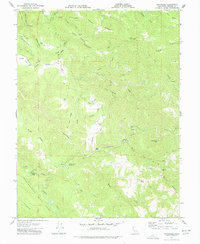
1977 Map of Annapolis
USGS Topo · Published 1978About this map
The San Andreas Rift Zone cuts a distinct path through the southern portion of this landscape, defining the complex drainage patterns of the South Fork Gualala River and the Wheatfield Fork Gualala River. In the northwest, the settlement of Annapolis serves as a focal point near Horicon Sch, surrounded by ridges bearing family names such as Beatty Ridge and Evans Ridge. A remote network of fire protection and recreation is evident through the Mendocoma Forest Fire Sta and a YMCA Camp complete with a Footbridge.
Find a feature on this map
55 named features on this map. Tap any name to fly to it.
Don’t see what you’re looking for? This feature index may not catch every label — zoom into the map to look around manually.
Map Details
Editions of this 1977 Annapolis Map
3 editions found
Other maps of this area

1921 · Skaggs
USGS Topo · 1:62,500

1921 · Plantation
USGS Topo · 1:62,500

1938 · Hopland
USGS Topo · 1:62,500

1943 · Tombs Creek
USGS Topo · 1:24,000

1943 · Stewarts Point
USGS Topo · 1:24,000

1943 · Plantation
USGS Topo · 1:24,000

1943 · Annapolis
USGS Topo · 1:24,000

1943 · Fort Ross
USGS Topo · 1:24,000

1943 · Hopland
USGS Topo · 1:62,500

1943 · Ornbaun
USGS Topo · 1:62,500