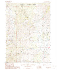
1986 Map of Annie Creek
USGS Topo · Published 1987About this map
The high Nevada landscape of the Humboldt National Forest is defined here by the headwaters of the Bruneau River and its intricate network of feeding creeks. This 1980s provisional survey illustrates a remote region of Elko County where cattle ranching and mining have long left their mark. Notable named locations like Inez, Cassidy, and Dolly indicate historical hubs of activity amid the broken terrain of the Rough Hills. Prospectors and mineral hunters will find numerous prospects and open pit mines concentrated in the northeastern portion of the quadrangle near the Badger Creek area.
Find a feature on this map
42 named features on this map. Tap any name to fly to it.
Don’t see what you’re looking for? This feature index may not catch every label — zoom into the map to look around manually.
Map Details
Editions of this 1986 Annie Creek Map
This is the sole edition of this map. No revisions or reprints were ever made.
Other maps of this area

1935 · Charleston
USGS Topo · 1:48,000

1936 · Rowland
USGS Topo · 1:48,000

1940 · Rowland
USGS Topo · 1:62,500

1942 · Mt. Velma
USGS Topo · 1:62,500

1943 · Jarbidge
USGS Topo · 1:62,500

1945 · Jarbidge
USGS Topo · 1:62,500

1955 · Wells
USGS Topo · 1:250,000

1958 · Wells
USGS Topo · 1:250,000

1961 · Wells
USGS Topo · 1:250,000

1968 · Charleston Reservoir
USGS Topo · 1:24,000