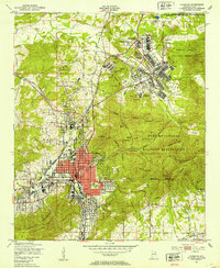
1947 Map of Anniston
USGS Topo · Published 1953About this map
Anniston serves as the industrial and civic anchor of this 1940s landscape, its grid layout extending toward the foothills of the Skeleton Mountains and Coldwater Mountain. The city is a major junction for the Southern Railway and the Louisville and Nashville RR, reflecting its mid-century importance as a transportation hub. Dominating the northeastern portion of the sheet is the Fort Mc Clellan Military Reservation, which includes a Prisoner of War Camp, an abandoned Reilly Airfield, and numerous training facilities like the Amphitheater and various rifle ranges. Local history is preserved in the location of the Thankful Schools and several burial grounds, including Halls Chapel Cem and Highland Cem. Smaller outlying communities such as Blue Mountain and De Armanville sit on the periphery, illustrating the post-war settlement pattern of Calhoun County.
Find a feature on this map
74 named features on this map. Tap any name to fly to it.
Don’t see what you’re looking for? This feature index may not catch every label — zoom into the map to look around manually.
Map Details
Editions of this 1947 Anniston Map
2 editions found
Other maps of this area

1900 · Anniston
USGS Topo · 1:125,000

1947 · Oxford
USGS Topo · 1:24,000

1947 · Anniston
USGS Topo · 1:24,000

1947 · Jacksonville
USGS Topo · 1:24,000

1947 · Wellington
USGS Topo · 1:24,000

1947 · Jacksonville
USGS Topo · 1:62,500

1947 · Eulaton
USGS Topo · 1:24,000

1947 · Munford
USGS Topo · 1:24,000

1950 · Anniston
USGS Topo · 1:62,500

1953 · Atlanta
USGS Topo · 1:250,000