
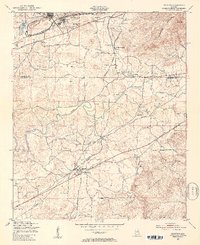
1947 Map of Munford
USGS Topo · Published 1953About this map
The Anniston Ordnance Depot dominates the northwestern corner of this landscape, marking a period of significant military infrastructure near Anniston. Just south of the military reservation, the terrain transitions into a patchwork of rural communities and rail-side settlements. The Southern and Louisville and Nashville railroads intersect the region, facilitating the movement of goods through Munford and Jenifer. These tracks parallel the winding path of Choccolocco Creek, which snakes through the valley between Coldwater Mountain and the Talladega National Forest.
Find a feature on this map
43 named features on this map. Tap any name to fly to it.
Don’t see what you’re looking for? This feature index may not catch every label — zoom into the map to look around manually.
Map Details
Editions of this 1947 Munford Map
2 editions found
Other maps of this area

1889 · Springville
USGS Topo · 1:125,000

1890 · Talladega
USGS Topo · 1:125,000

1891 · Ashland
USGS Topo · 1:125,000

1892 · Springville
USGS Topo · 1:125,000

1892 · Talladega
USGS Topo · 1:125,000

1900 · Anniston
USGS Topo · 1:125,000

1943 · Talladega
USGS Topo · 1:62,500

1946 · Talladega
USGS Topo · 1:62,500

1947 · Oxford
USGS Topo · 1:24,000

1947 · Anniston
USGS Topo · 1:24,000