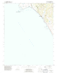
1991 Map of Ano Nuevo
USGS Topo · Published 1995About this map
The dramatic coastal boundary of Santa Cruz and San Mateo counties defines this 1991 revision, where the Santa Cruz Mountains meet the Pacific. The landscape is dominated by protected lands, including the massive Big Basin Redwoods State Park and the ecologically significant Theodore J. Hoover Natural Preserve. At the northwestern edge, Punta del Año Nuevo and Point Año Nuevo extend into the sea, while Año Nuevo Island sits just offshore as part of the surrounding Año Nuevo State Reserve. Narrow drainages like Waddell Creek and Scott Creek cut through the uplifted terrain toward Año Nuevo Bay. This map traces a transition from dense redwood forests to coastal bluffs, showing minimal development aside from the winding Last Chance Road and a solitary Cemetery tucked near the ridges above Arroyo de las Trancas.
Find a feature on this map
28 named features on this map. Tap any name to fly to it.
Don’t see what you’re looking for? This feature index may not catch every label — zoom into the map to look around manually.
Map Details
Editions of this 1991 Ano Nuevo Map
This is the sole edition of this map. No revisions or reprints were ever made.
Other maps of this area

1902 · Santa Cruz
USGS Topo · 1:125,000

1940 · Ano Nuevo
USGS Topo · 1:62,500

1941 · Ano Nuevo Pt.
USGS Topo · 1:62,500

1942 · Ano Nuevo
USGS Topo · 1:62,500

1947 · San Francisco
USGS Topo · 1:250,000

1948 · San Francisco
USGS Topo · 1:250,000

1948 · Ano Nuevo
USGS Topo · 1:62,500

1955 · San Francisco
USGS Topo · 1:250,000
1955 · Pigeon Point
USGS Topo · 1:24,000
1955 · Ano Nuevo
USGS Topo · 1:24,000