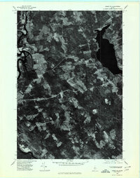
1975 Map of Anson SE
USGS Topo · Published 1980About this map
Kennebec River bends through this landscape in the mid-1970s, anchoring a region of farm clearings and dense woodlands in Somerset County. This orthophotoquad provides a precise visual record of rural Maine, showing the distinct patchwork of timber and open fields that defined the local economy during this era. Several small crossroads and settlements are visible, including East Madison and Madison, which reveal the residential patterns of the time. The imagery captured in late October also shows the established road network linking local hubs like Blackwell Corner, Lakewood, and Martin Corner. For those studying land use or genealogy, these aerial details offer an exact look at property boundaries and rural development before modern suburban expansion.
Find a feature on this map
6 named features on this map. Tap any name to fly to it.
Don’t see what you’re looking for? This feature index may not catch every label — zoom into the map to look around manually.
Map Details
Editions of this 1975 Anson SE Map
This is the sole edition of this map. No revisions or reprints were ever made.
Other maps of this area

1892 · Waterville
USGS Topo · 1:62,500

1894 · Norridgewock
USGS Topo · 1:62,500

1898 · Norridgewock
USGS Topo · 1:62,500

1904 · Anson
USGS Topo · 1:62,500

1913 · Skowhegan
USGS Topo · 1:62,500

1943 · Norridgewock
USGS Topo · 1:62,500

1943 · Waterville
USGS Topo · 1:62,500

1948 · Bangor
USGS Topo · 1:250,000

1955 · Anson
USGS Topo · 1:62,500

1955 · Skowhegan
USGS Topo · 1:62,500