
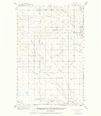
1943 Map of Antelope Coulee
USGS Topo · Published 1945About this map
Fifteenmile Coulee and Antelope Coulee carve through this Toole County landscape, where early 1940s land use is defined by isolated ranching outposts and a sparse network of section-line roads. The area, mapped shortly after the Great Depression, reveals the established presence of family operations like Johannson Ranch and Ekholt Ranch, located near the northern drainage of Black Coulee. The local infrastructure is oriented around these homesteads and the Fairview Sch, which served the scattered community. The Principal Meridian bisects the quadrangle, serving as a critical reference point for the rectilinear survey grid that dictates the placement of Morton Road and Telstad Road. Beyond the watercourses, the terrain rises toward Black Butte in the northeast, while numerous windmills and isolated wells highlight the precarious nature of water management in this high plains environment.
Find a feature on this map
20 named features on this map. Tap any name to fly to it.
Don’t see what you’re looking for? This feature index may not catch every label — zoom into the map to look around manually.
Map Details
Editions of this 1943 Antelope Coulee Map
2 editions found
Other maps of this area

1920 · Conrad
USGS Topo · 1:125,000

1939 · Sunburst
USGS Topo · 1:62,500

1943 · Shelby
USGS Topo · 1:62,500

1945 · West Butte
USGS Topo · 1:62,500

1954 · Shelby
USGS Topo · 1:250,000

1958 · Shelby
USGS Topo · 1:250,000

1962 · Cameron Lake
USGS Topo · 1:24,000

1962 · Hawthorne School
USGS Topo · 1:24,000

1962 · Mc Carters Lake
USGS Topo · 1:24,000

1967 · Naismith
USGS Topo · 1:24,000