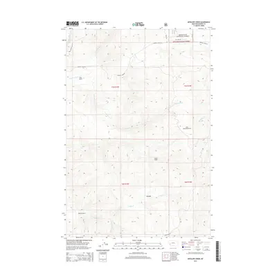
2014 Map of Antelope Creek
USGS Topo · Published 2014About this map
Deerlodge National Forest encompasses the high terrain of the John Long Mountains in this modern topographic study of Granite County. The landscape is defined by a dense network of drainages and gulches, including Sluice Gulch, Trail Gulch, and Wildcat Gulch, reflecting the complex topography typical of the Northern Rockies. The lower elevations near Corral are shaped by the paths of Antelope Cr and its southern fork, while the northwestern portion is marked by Upper Willow Cr. Human presence is concentrated along primitive and forest roads such as Marshall Creek Rd and Rock Creek Rd, providing access for land management and recreation within the national forest boundaries. The map provides a precise look at the township and range divisions of T7N R15W and T6N R14W, illustrating the intersection of public land and rugged Montana wilderness.
Find a feature on this map
22 named features on this map. Tap any name to fly to it.
Don’t see what you’re looking for? This feature index may not catch every label — zoom into the map to look around manually.
Map Details
Editions of this 2014 Antelope Creek Map
This is the sole edition of this map. No revisions or reprints were ever made.
Other maps of this area

1908 · Philipsburg
USGS Topo · 1:125,000

1909 · Sapphire
USGS Topo · 1:125,000

1947 · Butte
USGS Topo · 1:250,000

1958 · Butte
USGS Topo · 1:250,000

1960 · Butte
USGS Topo · 1:250,000

1962 · Butte
USGS Topo · 1:250,000

1971 · Henderson Mountain
USGS Topo · 1:24,000

1971 · Georgetown Lake
USGS Topo · 1:24,000

1971 · Antelope Creek
USGS Topo · 1:24,000

1971 · Potato Lakes
USGS Topo · 1:24,000