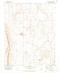
1971 Map of Antelope Knoll
USGS Topo · Published 1973About this map
The Hurricane Cliffs dominate the western edge of this Mohave County landscape, creating a dramatic vertical transition across the high desert terrain. This 1971 survey captures a remote ranching and grazing environment defined by its water management, where numerous tanks and reservoirs like the Temple Trail Tank and Bobcat Reservoir provide the only reliable water sources. The area is marked by a series of volcanic features and basaltic outcrops known as the Black Rocks, which rise above the surrounding flats of Lonesome Valley. Distinctive peaks such as Antelope Knoll, Maryland Knoll, and Deadman Knoll serve as primary landmarks for navigation across the basin. The presence of named water features like McBryde Reservoir and Spendlave Tank reflects the essential infrastructure required for desert land use during this era.
Find a feature on this map
17 named features on this map. Tap any name to fly to it.
Don’t see what you’re looking for? This feature index may not catch every label — zoom into the map to look around manually.
Map Details
Editions of this 1971 Antelope Knoll Map
This is the sole edition of this map. No revisions or reprints were ever made.
Other maps of this area

1886 · Mt. Trumbull
USGS Topo · 1:250,000

1892 · Mt. Trumbull
USGS Topo · 1:250,000

1953 · Grand Canyon
USGS Topo · 1:250,000

1954 · Lost Spring SE
USGS Topo · 1:24,000
1954 · Lost Spring Mtn
USGS Topo · 1:62,500

1957 · Grand Canyon
USGS Topo · 1:250,000

1958 · Grand Canyon
USGS Topo · 1:250,000

1960 · Grand Canyon
USGS Topo · 1:250,000
1971 · Moriah Knoll
USGS Topo · 1:24,000
1971 · Little Clayhole Valley
USGS Topo · 1:24,000