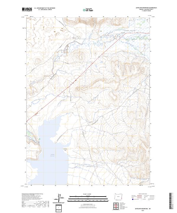
2024 Map of Antelope Reservoir
USGS Topo · Published 2024About this map
Jordan Valley anchors this high-desert landscape in southeastern Oregon, where a sophisticated network of water management defines the local geography. The Antelope Reservoir dominates the southwestern portion of the sheet, supported by an intricate system of waterways including the Antelope Feeder Canal, North Antelope Canal, and South Antelope Canal. These engineered features contrast with the natural winding course of Jordan Creek as it carves through Jordan Creek Canyon. Remote ranching and agricultural access are established through a series of long-distance routes such as Danner Rd and Jack Creek Rd, which traverse the wide expanses of Antelope Flat. The map documents a rugged landscape where historical grazing lands and modern irrigation infrastructure meet, specifically tracing the path of Hooker Creek and Sheep Spring Creek as they feed into the valley floor.
Find a feature on this map
26 named features on this map. Tap any name to fly to it.
Don’t see what you’re looking for? This feature index may not catch every label — zoom into the map to look around manually.
Map Details
Editions of this 2024 Antelope Reservoir Map
This is the sole edition of this map. No revisions or reprints were ever made.
Other maps of this area

1955 · Jordan Valley
USGS Topo · 1:250,000

1955 · Boise
USGS Topo · 1:250,000

1957 · Jordan Valley
USGS Topo · 1:250,000

1958 · Boise
USGS Topo · 1:250,000

1958 · Jordan Valley
USGS Topo · 1:250,000

1962 · Boise
USGS Topo · 1:250,000
1969 · Little Grassy Mountain
USGS Topo · 1:24,000
1969 · Juniper Ridge
USGS Topo · 1:24,000
1969 · Hooker Creek
USGS Topo · 1:24,000

1969 · Cow Lakes
USGS Topo · 1:24,000