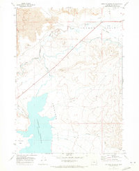
1969 Map of Antelope Reservoir
USGS Topo · Published 1973About this map
Antelope Reservoir dominates the lower half of this late 1960s survey, representing a significant water management hub in the high desert of Malheur County. The map documents an intricate irrigation network designed to sustain the arid landscape, including the Antelope Feeder Canal and numerous springs like Sheep Spring. To the north, the terrain is characterized by expansive Lava beds and the winding course of Jordan Creek, which cuts through the volcanic geology. Small-scale human activity is evident in the scattered Borrow Pits and the sparse settlement at Antelope Flat. The topography transitions from the flat expanses of Antelope Flat to the more varied elevations of Danner Valley, illustrating the intersection of geologic history and agricultural development in this corner of the Jordan Valley.
Find a feature on this map
16 named features on this map. Tap any name to fly to it.
Don’t see what you’re looking for? This feature index may not catch every label — zoom into the map to look around manually.
Map Details
Editions of this 1969 Antelope Reservoir Map
This is the sole edition of this map. No revisions or reprints were ever made.
Other maps of this area

1955 · Jordan Valley
USGS Topo · 1:250,000

1955 · Boise
USGS Topo · 1:250,000

1957 · Jordan Valley
USGS Topo · 1:250,000

1958 · Boise
USGS Topo · 1:250,000

1958 · Jordan Valley
USGS Topo · 1:250,000

1962 · Boise
USGS Topo · 1:250,000
1969 · Little Grassy Mountain
USGS Topo · 1:24,000
1969 · Juniper Ridge
USGS Topo · 1:24,000
1969 · Hooker Creek
USGS Topo · 1:24,000

1969 · Cow Lakes
USGS Topo · 1:24,000