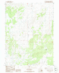
1986 Map of Antelope Valley
USGS Topo · Published 1986About this map
Antelope Valley occupies a significant portion of this high-desert landscape in the mid-1980s, shaped by volcanic features and the sparse infrastructure of the Great Basin. The terrain is dominated by the volcanic forms of Lava Ridge, which rises over the northern portion of the quadrangle. Transport and movement through this area are defined by Government Pass, a critical point of passage through the ridges that separate the drainage basins. Water management is evident at the South Horse Hollow Reservoir, a vital catchment for the seasonal flows that eventually reach Cove Creek in the south. This survey, compiled from mid-century aerial photography with updates in the 1980s, documents a landscape primarily used for rangeland and resource extraction, as seen in the isolated Gravel Pit.
Find a feature on this map
8 named features on this map. Tap any name to fly to it.
Don’t see what you’re looking for? This feature index may not catch every label — zoom into the map to look around manually.
Map Details
Editions of this 1986 Antelope Valley Map
This is the sole edition of this map. No revisions or reprints were ever made.
Other maps of this area

1885 · Beaver
USGS Topo · 1:250,000

1953 · Richfield
USGS Topo · 1:250,000

1958 · Richfield
USGS Topo · 1:250,000

1962 · Tabernacle Hill
USGS Topo · 1:62,500

1962 · Cove Fort
USGS Topo · 1:62,500

1973 · Cruz
USGS Topo · 1:24,000

1973 · Pinnacle Pass
USGS Topo · 1:24,000

1973 · Antelope Spring
USGS Topo · 1:24,000

1980 · Richfield
USGS Topo · 1:100,000
1986 · Sixmile Point
USGS Topo · 1:24,000