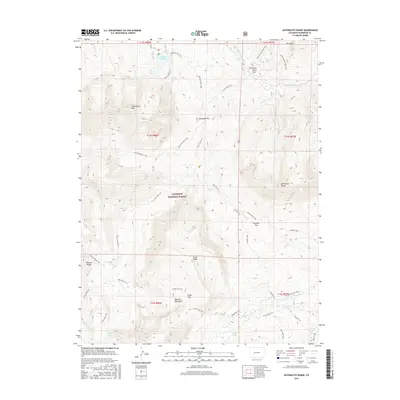
2016 Map of Anthracite Range
USGS Topo · Published 2016About this map
Gunnison National Forest dominates this high-elevation landscape, where the Anthracite Range and West Elk Mountains define the local topography. This 2016 survey captures a network of trails and mountain passes essential for navigating the complex terrain of Gunnison County. Significant alpine water bodies including Lost Lake Slough, Lost Lake, and Dollar Lake are clustered near the base of E Beckwith Mtn, illustrating the importance of glacial basins in the region's hydrology. Historical movement through the area is evidenced by established routes like Swampy Pass Trail and Castle Pass Trail, which connect distinct drainages such as Ruby Anthracite Cr and Cliff Creek. Notable landmarks such as The Dyke and Storm Ridge offer insight into the geological character of this section of the Rocky Mountains, while Horse Ranch Park provides a grounded point of reference within the forest boundaries.
Find a feature on this map
42 named features on this map. Tap any name to fly to it.
Don’t see what you’re looking for? This feature index may not catch every label — zoom into the map to look around manually.
Map Details
Editions of this 2016 Anthracite Range Map
This is the sole edition of this map. No revisions or reprints were ever made.
Other maps of this area

1888 · Anthracite
USGS Topo · 1:62,500

1889 · Anthracite
USGS Topo · 1:62,500

1893 · Anthracite
USGS Topo · 1:62,500

1894 · Anthracite
USGS Topo · 1:62,500

1938 · Mt. Gunnison
USGS Topo · 1:48,000

1945 · Mount Gunnison
USGS Topo · 1:62,500

1956 · Montrose
USGS Topo · 1:250,000

1959 · Montrose
USGS Topo · 1:250,000

1960 · Montrose
USGS Topo · 1:250,000
1961 · Oh-Be-Joyful
USGS Topo · 1:24,000