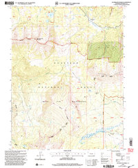
2001 Map of Anthracite Range
USGS Topo · Published 2004About this map
East Beckwith Mountain and the towering Anthracite Range dominate this high-altitude landscape within the Gunnison National Forest. Revised by the Forest Service at the turn of the 21st century, the map provides a look at the preserved backcountry of the West Elk Wilderness. High mountain passes serve as critical navigational nodes, including Beckwith Pass, Swampy Pass, and Castle Pass, connecting deep drainages like Castle Creek and Cliff Creek.
Find a feature on this map
30 named features on this map. Tap any name to fly to it.
Don’t see what you’re looking for? This feature index may not catch every label — zoom into the map to look around manually.
Map Details
Editions of this 2001 Anthracite Range Map
This is the sole edition of this map. No revisions or reprints were ever made.
Other maps of this area

1888 · Anthracite
USGS Topo · 1:62,500

1889 · Anthracite
USGS Topo · 1:62,500

1893 · Anthracite
USGS Topo · 1:62,500

1894 · Anthracite
USGS Topo · 1:62,500

1938 · Mt. Gunnison
USGS Topo · 1:48,000

1945 · Mount Gunnison
USGS Topo · 1:62,500

1956 · Montrose
USGS Topo · 1:250,000

1959 · Montrose
USGS Topo · 1:250,000

1960 · Montrose
USGS Topo · 1:250,000
1961 · Oh-Be-Joyful
USGS Topo · 1:24,000