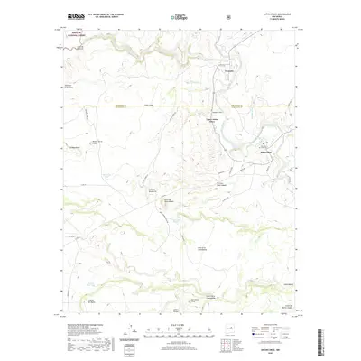
2020 Map of Anton Chico
USGS Topo · Published 2020About this map
The Pecos River carves a winding path through this corner of Northern New Mexico, where the communities of Anton Chico, Upper Anton Chico, and Tecolotito sit along its banks. This landscape is defined by its series of mesas and canyons, including La Mesa Parda and Cañon de la Chamizalosa, which transition into the southeastern reaches of the Santa Fe National Forest. The map captures a high-desert environment where water management is vital, evidenced by labels for the Montecitos Tank and Camilo Saiz Tank. Local history is anchored by the Old Anton Chico Cem and family-named landmarks like Ben Ortiz Peak. A network of rural routes such as Cueva Del Padre Rd and La Merced Rd connect these riverside settlements to the higher grazing lands of Llano Largo and La Mesa Del Medio.
Find a feature on this map
43 named features on this map. Tap any name to fly to it.
Don’t see what you’re looking for? This feature index may not catch every label — zoom into the map to look around manually.
Map Details
Editions of this 2020 Anton Chico Map
This is the sole edition of this map. No revisions or reprints were ever made.
Other maps of this area

1890 · Bernal
USGS Topo · 1:125,000

1891 · Bernal
USGS Topo · 1:125,000

1894 · Bernal
USGS Topo · 1:125,000

1954 · Santa Fe
USGS Topo · 1:250,000

1958 · Santa Fe
USGS Topo · 1:250,000

1960 · Villanueva
USGS Topo · 1:62,500

1960 · Apache Springs
USGS Topo · 1:62,500
1963 · Thompson Ranch
USGS Topo · 1:24,000
1963 · Anton Chico
USGS Topo · 1:24,000
1963 · Mesa Palo Amarillo
USGS Topo · 1:24,000