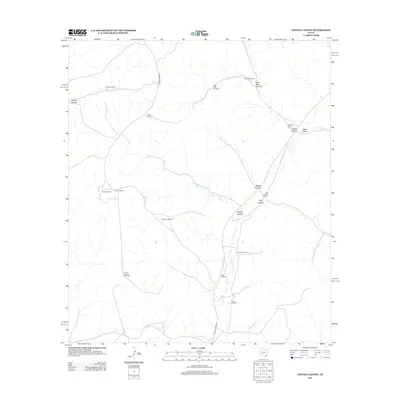
2012 Map of Antone Canyon
USGS Topo · Published 2012About this map
Antone Canyon and the surrounding high country of Val Verde County define a landscape where water management is the primary marker of human presence. In this arid region, the network of life is traced through a series of named windmills rather than established towns. Features like Glade Windmill, Cayetano Windmill, and House Canyon Windmill indicate the vital infrastructure required for cattle ranching. The presence of Mitchell Ranch and Blakeney Ranch shows the continuity of land use in a terrain etched by deep drainages such as Dog Canyon, Horse Canyon, and Jesus Canyon. Remote transit is facilitated by Hoover Divide Rd and Ranch Road 2083, connecting these isolated outposts across the divide.
Find a feature on this map
22 named features on this map. Tap any name to fly to it.
Don’t see what you’re looking for? This feature index may not catch every label — zoom into the map to look around manually.
Map Details
Editions of this 2012 Antone Canyon Map
This is the sole edition of this map. No revisions or reprints were ever made.
Other maps of this area

1954 · Sonora
USGS Topo · 1:250,000

1958 · Sonora
USGS Topo · 1:250,000

1970 · Antone Canyon
USGS Topo · 1:24,000

1970 · Pandale
USGS Topo · 1:24,000

1970 · Howards Well
USGS Topo · 1:24,000

1970 · Howards Well SW
USGS Topo · 1:24,000
1970 · Divide Well Draw
USGS Topo · 1:24,000
1970 · Prince Albert Draw
USGS Topo · 1:24,000

1973 · Post Canyon
USGS Topo · 1:24,000
1973 · Hackberry Crossing
USGS Topo · 1:24,000