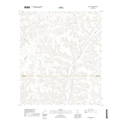
2019 Map of Antone Canyon
USGS Topo · Published 2019About this map
Howard Draw serves as the central drainage feature in this high-desert landscape, carved by a network of deep-cut canyons. This 2019 survey documents the borderlands where Val Verde and Crockett counties meet, a region defined by its isolation and dramatic relief. The map illustrates a system of canyons including Antone Canyon, Jesus Canyon, and Wood Canyon, which all feed into the primary draw. The presence of Pandale Rd and Dog Canyon Trl provides evidence of the sparse road network necessary to navigate this complex terrain. The intersection of local infrastructure and natural topography is further highlighted by Co RD 406 and the Crockett Co Line Rd, which trace the ridge lines between the deep washes of Live Oak Canyon and Tanislado Canyon.
Find a feature on this map
19 named features on this map. Tap any name to fly to it.
Don’t see what you’re looking for? This feature index may not catch every label — zoom into the map to look around manually.
Map Details
Editions of this 2019 Antone Canyon Map
This is the sole edition of this map. No revisions or reprints were ever made.
Other maps of this area

1954 · Sonora
USGS Topo · 1:250,000

1958 · Sonora
USGS Topo · 1:250,000

1970 · Antone Canyon
USGS Topo · 1:24,000

1970 · Pandale
USGS Topo · 1:24,000

1970 · Howards Well
USGS Topo · 1:24,000

1970 · Howards Well SW
USGS Topo · 1:24,000
1970 · Divide Well Draw
USGS Topo · 1:24,000
1970 · Prince Albert Draw
USGS Topo · 1:24,000

1973 · Post Canyon
USGS Topo · 1:24,000
1973 · Hackberry Crossing
USGS Topo · 1:24,000