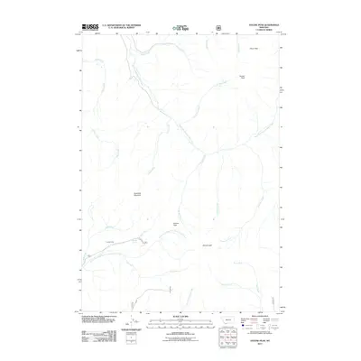
2011 Map of Antone Peak
USGS Topo · Published 2011About this map
Antone Peak and the surrounding high country of Beaverhead County define this landscape, where the headwaters of the East Fork Blacktail Deer Creek and South Fork West Fork Blacktail Deer Creek converge. The topography is shaped by prominent heights such as Sawtooth Mountain, Olson Peak, and Sunset Peak, providing a clear view of the drainage patterns in this corner of Montana. Human activity in this high-elevation area is marked by Cornell Camp and the winding route of Antone Rd, which crosses through Antone Pass. Water sources are vital here, with Seybold Spring feeding into the Bonita Fork and a network of named streams including Alkali Creek, Indian Creek, and West Creek carving out the terrain. This map serves as a primary record of the watershed and seasonal access points in a region dominated by its namesake peaks and vast drainage basins.
Find a feature on this map
25 named features on this map. Tap any name to fly to it.
Don’t see what you’re looking for? This feature index may not catch every label — zoom into the map to look around manually.
Map Details
Editions of this 2011 Antone Peak Map
This is the sole edition of this map. No revisions or reprints were ever made.
Other maps of this area

1955 · Dubois
USGS Topo · 1:250,000

1958 · Dubois
USGS Topo · 1:250,000

1968 · Stonehouse Mountain
USGS Topo · 1:24,000

1968 · Whiskey Spring
USGS Topo · 1:24,000

1968 · Lima Dam
USGS Topo · 1:24,000
1968 · Price Creek NE
USGS Topo · 1:24,000

1968 · Antelope Peak
USGS Topo · 1:24,000

1968 · Antone Peak
USGS Topo · 1:24,000
1968 · Swamp Creek
USGS Topo · 1:24,000
1968 · Wolverine Creek
USGS Topo · 1:24,000