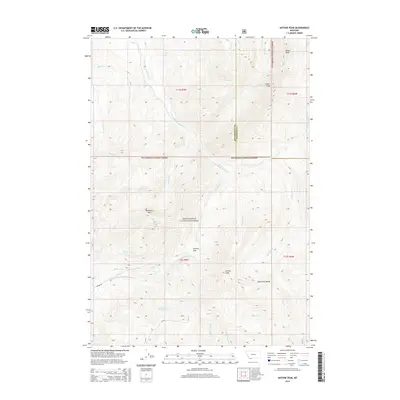
2014 Map of Antone Peak
USGS Topo · Published 2014About this map
Antone Peak serves as a prominent high point in this 2014 survey of the southern Snowcrest Range. Located within the Beaverhead National Forest, the landscape is defined by the high-elevation divide between Beaverhead and Madison counties. Historical water rights and high-country transit are marked by features like Seybold Spring and the Antone Pass. The map details a complex network of drainage headwaters, including the Clark Fork, Dukes Fork, and multiple branches of the E Fork Blacktail Deer Creek. The presence of Antone Rd provides the primary access through this mountainous terrain, where peaks such as Sawtooth Mtn and Sunset Peak tower over the creek valleys. This map is particularly useful for understanding the modern forest boundaries and the source waters of several significant regional tributaries.
Find a feature on this map
32 named features on this map. Tap any name to fly to it.
Don’t see what you’re looking for? This feature index may not catch every label — zoom into the map to look around manually.
Map Details
Editions of this 2014 Antone Peak Map
This is the sole edition of this map. No revisions or reprints were ever made.
Other maps of this area

1955 · Dubois
USGS Topo · 1:250,000

1958 · Dubois
USGS Topo · 1:250,000

1968 · Stonehouse Mountain
USGS Topo · 1:24,000

1968 · Whiskey Spring
USGS Topo · 1:24,000

1968 · Lima Dam
USGS Topo · 1:24,000
1968 · Price Creek NE
USGS Topo · 1:24,000

1968 · Antelope Peak
USGS Topo · 1:24,000

1968 · Antone Peak
USGS Topo · 1:24,000
1968 · Swamp Creek
USGS Topo · 1:24,000
1968 · Wolverine Creek
USGS Topo · 1:24,000