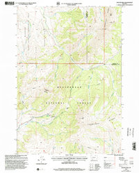
1997 Map of Antone Peak
USGS Topo · Published 2002About this map
The Snowcrest Range dominates the eastern high ground of this landscape, where the headwaters of the East Fork Blacktail Deer Creek begin their descent. This 1990s revision of earlier topography documents the intersection of working forest and conservation, where the Beaverhead National Forest meets a dedicated State Wildlife Management Area. Human presence is concentrated at the Antone Guard Station and Cornell Camp, reflecting the management of these remote Montana highlands for wildlife and resource preservation. The drainage system is intricate, with numerous named water sources like Seybold Spring and Indian Spring feeding the forks of the Blacktail Deer Creek. A primitive network of trails, including the Sawtooth Trail and Lodgepole Trail, connects high-elevation landmarks such as Antone Pass and Sawtooth Mountain, providing a detailed look at the backcountry infrastructure used by rangers and researchers at the end of the twentieth century.
Find a feature on this map
37 named features on this map. Tap any name to fly to it.
Don’t see what you’re looking for? This feature index may not catch every label — zoom into the map to look around manually.
Map Details
Editions of this 1997 Antone Peak Map
This is the sole edition of this map. No revisions or reprints were ever made.
Other maps of this area

1955 · Dubois
USGS Topo · 1:250,000

1958 · Dubois
USGS Topo · 1:250,000

1968 · Stonehouse Mountain
USGS Topo · 1:24,000

1968 · Whiskey Spring
USGS Topo · 1:24,000

1968 · Lima Dam
USGS Topo · 1:24,000
1968 · Price Creek NE
USGS Topo · 1:24,000

1968 · Antelope Peak
USGS Topo · 1:24,000

1968 · Antone Peak
USGS Topo · 1:24,000
1968 · Swamp Creek
USGS Topo · 1:24,000
1968 · Wolverine Creek
USGS Topo · 1:24,000