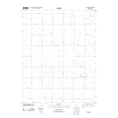
2012 Map of Antonino
USGS Topo · Published 2012About this map
Antonino serves as the central hub of this Ellis County landscape, situated amidst a systematic grid of section roads that define the region's agricultural and industrial layout. The settlement itself is modest, with a small network of streets including 1st St and Frederic St providing a clear view of its mid-century residential footprint. To the south, the Smoky Hill River meanders across the bottom of the sheet, while the presence of the Irvin Oil Field indicates the ongoing importance of energy extraction to the local economy. Historians and genealogists may find interest in the intersection of traditional transit routes and modern infrastructure, particularly where the Butterfield Trl crosses north-south avenues like 180th Ave. This survey illustrates a quiet prairie community where the high plains landscape is dominated by long-range vistas and the steady rhythm of oil production.
Find a feature on this map
24 named features on this map. Tap any name to fly to it.
Don’t see what you’re looking for? This feature index may not catch every label — zoom into the map to look around manually.
Map Details
Editions of this 2012 Antonino Map
This is the sole edition of this map. No revisions or reprints were ever made.
Other maps of this area
1893 · Ellis
USGS Topo · 1:125,000
1896 · Hays
USGS Topo · 1:125,000

1955 · Great Bend
USGS Topo · 1:250,000

1957 · Great Bend
USGS Topo · 1:250,000

1958 · Great Bend
USGS Topo · 1:250,000
1961 · Yocemento
USGS Topo · 1:24,000
1961 · Hays South
USGS Topo · 1:24,000
1961 · Hays North
USGS Topo · 1:24,000
1961 · Antonino
USGS Topo · 1:24,000
1961 · Ellis
USGS Topo · 1:24,000