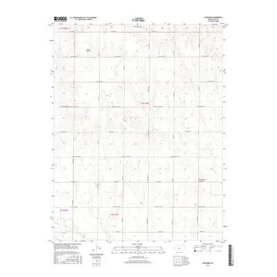
2015 Map of Antonino
USGS Topo · Published 2015About this map
Antonino serves as the primary settlement within this section of the High Plains, situated at the intersection of Antonino Rd and 210th Ave. The landscape is defined by the gradual southward descent toward the Smoky Hill River, which cuts across the bottom of the map. To the north, the terrain rises into higher ground broken by Lookout Hollow, a prominent drainage feature. This 2015 survey illustrates a highly structured agricultural grid, with section roads such as Victoria Rd and Spring Hill Rd partitioning the countryside. A notable historical layer is preserved in the naming of Butterfield Trail Rd, referencing the legacy of mid-19th-century overland transit across Kansas. The map provides a detailed view of modern rural infrastructure, including localized routes like Munjor Rd and Mount Pleasant Rd that connect the farmsteads of Ellis County.
Find a feature on this map
24 named features on this map. Tap any name to fly to it.
Don’t see what you’re looking for? This feature index may not catch every label — zoom into the map to look around manually.
Map Details
Editions of this 2015 Antonino Map
This is the sole edition of this map. No revisions or reprints were ever made.
Other maps of this area

1893 · Ellis
USGS Topo · 1:125,000

1896 · Hays
USGS Topo · 1:125,000

1955 · Great Bend
USGS Topo · 1:250,000

1957 · Great Bend
USGS Topo · 1:250,000

1958 · Great Bend
USGS Topo · 1:250,000

1961 · Yocemento
USGS Topo · 1:24,000

1961 · Hays South
USGS Topo · 1:24,000
1961 · Hays North
USGS Topo · 1:24,000

1961 · Antonino
USGS Topo · 1:24,000
1961 · Ellis
USGS Topo · 1:24,000