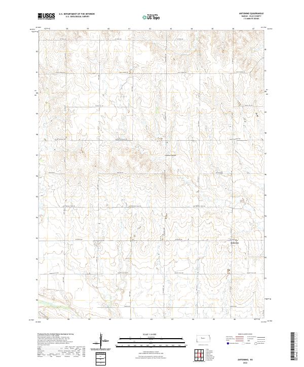
2022 Map of Antonino
USGS Topo · Published 2022About this map
Antonino serves as the primary community focal point in this portion of Ellis County, situated along the east-west corridor of Antonino Rd. The landscape is defined by the drainage patterns of the Smoky Hill River, which cuts through the southwestern corner of the quadrangle. North of the river, the terrain is shaped by several significant depressions and landmarks, most notably the prominent Lookout Hollow. The road network follows a strict section-line grid, typical of the High Plains, yet carries names that evoke the region's pioneering history. Routes such as Butterfield Trail Rd and Chetolah Gold Rd hint at the historic transit and prospecting efforts that once crossed these Kansas prairies. This survey provides a clear view of how modern rural infrastructure, including Munjor Rd and Grants Villa Rd, overlays the ancestral land divisions of the T14S and T15S townships.
Find a feature on this map
26 named features on this map. Tap any name to fly to it.
Don’t see what you’re looking for? This feature index may not catch every label — zoom into the map to look around manually.
Map Details
Editions of this 2022 Antonino Map
This is the sole edition of this map. No revisions or reprints were ever made.
Other maps of this area

1893 · Ellis
USGS Topo · 1:125,000

1896 · Hays
USGS Topo · 1:125,000

1955 · Great Bend
USGS Topo · 1:250,000

1957 · Great Bend
USGS Topo · 1:250,000

1958 · Great Bend
USGS Topo · 1:250,000

1961 · Yocemento
USGS Topo · 1:24,000

1961 · Hays South
USGS Topo · 1:24,000
1961 · Hays North
USGS Topo · 1:24,000

1961 · Antonino
USGS Topo · 1:24,000
1961 · Ellis
USGS Topo · 1:24,000