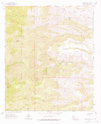
1963 Map of Apache Peak
USGS Topo · Published 1975About this map
Apache Peak and the surrounding high desert of the Gila National Forest define this landscape during the early 1960s. The map illustrates a complex network of canyons, including North Seco, Middle Seco, and South Seco, which converge as they move east. Human presence is sparse and tied directly to water sources and livestock grazing, evidenced by the L M Bar Ranch and the Dumm Place.
Find a feature on this map
56 named features on this map. Tap any name to fly to it.
Don’t see what you’re looking for? This feature index may not catch every label — zoom into the map to look around manually.
Map Details
Editions of this 1963 Apache Peak Map
2 editions found

Other maps of this area

1935 · Hillsboro
USGS Topo · 1:48,000

1940 · Hillsboro
USGS Topo · 1:62,500

1954 · Tularosa
USGS Topo · 1:250,000

1955 · Las Cruces
USGS Topo · 1:250,000

1956 · San Lorenzo
USGS Topo · 1:62,500

1958 · Las Cruces
USGS Topo · 1:250,000

1958 · Tularosa
USGS Topo · 1:250,000

1963 · Bell Mountain
USGS Topo · 1:24,000

1963 · Thumb Tank Peak
USGS Topo · 1:24,000

1963 · Reeds Peak
USGS Topo · 1:24,000