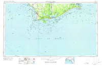
1967 Map of Apalachicola
USGS Topo · Published 1975About this map
The Apalachicola River serves as the central artery for this coastal region, meeting the sea at the historic town of Apalachicola. By the late 1960s, the landscape reflects a mix of maritime industry and conservation, with the Apalachicola Northern railroad connecting timber and fishing hubs like Port St Joe and Carrabelle. Strategic landmarks like the Cape St George Lighthouse and Fort Gadsden ground the map in the region's long navigational and military history, while the Marine Laboratory near St Teresa Beach marks the area's growing scientific interest. The expansive Tates Hell Swamp and Bear Swamp dominate the interior, illustrating the formidable wetland geography that constrained inland development. Coastal settlements such as Mexico Beach and Lanark Station appear alongside significant federal lands, including Tyndall Air Force Base and the St Marks National Wildlife Refuge.
Find a feature on this map
84 named features on this map. Tap any name to fly to it.
Don’t see what you’re looking for? This feature index may not catch every label — zoom into the map to look around manually.
Map Details
Editions of this 1967 Apalachicola Map
This is the sole edition of this map. No revisions or reprints were ever made.
Other maps of this area

1940 · Arran
USGS Topo · 1:62,500

1943 · Arran
USGS Topo · 1:62,500

1943 · St Joseph Spit
USGS Topo · 1:31,680

1943 · Beacon Beach
USGS Topo · 1:31,680

1943 · Port St. Joe
USGS Topo · 1:31,680

1943 · Cape San Blas
USGS Topo · 1:31,680

1943 · Dog Island
USGS Topo · 1:31,680

1943 · West Pass
USGS Topo · 1:31,680

1943 · Overstreet
USGS Topo · 1:31,680

1943 · Apalachicola
USGS Topo · 1:31,680