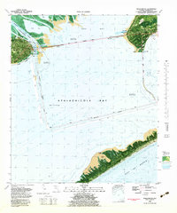
1982 Map of Apalachicola
USGS Topo · Published 1983About this map
The waterfront community of Apalachicola serves as the focal point of this 1982 topographic-bathymetric survey, positioned where the Apalachicola River meets the expansive Apalachicola Bay. This edition provides a detailed look at the coastal infrastructure of the early 1980s, featuring the John Gorrie Memorial Bridge spanning toward Eastpoint and the Patton Bridge crossing over Bulkhead Shoal. The map highlights the town's public spaces like Battery Park and Lafayette Park, alongside industrial and maritime markers such as the Mill Pond and the dredged routes of the Intracoastal Waterway. To the south, the barrier environment of St. George Island is visible, featuring Nicks Hole and Cedar Point, protecting the Upper Anchorage from the open waters of the Gulf of Mexico.
Find a feature on this map
35 named features on this map. Tap any name to fly to it.
Don’t see what you’re looking for? This feature index may not catch every label — zoom into the map to look around manually.
Map Details
Editions of this 1982 Apalachicola Map
This is the sole edition of this map. No revisions or reprints were ever made.
Other maps of this area

1943 · West Pass
USGS Topo · 1:31,680

1943 · Apalachicola
USGS Topo · 1:31,680

1943 · Jackson River
USGS Topo · 1:24,000

1944 · Green Point
USGS Topo · 1:31,680

1944 · Apalachicola
USGS Topo · 1:24,000

1945 · Cape St. George
USGS Topo · 1:31,680

1945 · Beverly
USGS Topo · 1:31,680

1945 · Jackson River
USGS Topo · 1:31,680

1949 · Apalachicola
USGS Topo · 1:250,000

1950 · Goose Island
USGS Topo · 1:31,680