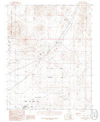
1986 Map of Apex
USGS Topo · Published 1986About this map
Arrolime and Apex sit at the intersection of heavy industry and military preservation in this mid-1980s Clark County landscape. The Union Pacific railroad cuts through the terrain, serving the extraction economy evidenced by a Rock Quarry and scattered Mine Shafts. The area is characterized by high-desert activity, from the Race Track near Apex to the industrial Gypsum operations. To the west, the Desert National Wildlife Range and Nellis Air Force Base border one another, marking a clear divide between protected wilderness and military testing grounds. The landscape itself is fluid, with Shifting Sand and the Las Vegas Dunes dominating the southern portion of the sheet. Gypsum Wash drains toward the vast expanse of the Dry Lake in the northeast, illustrating the arid drainage patterns of the Mojave before the intensification of regional development.
Find a feature on this map
25 named features on this map. Tap any name to fly to it.
Don’t see what you’re looking for? This feature index may not catch every label — zoom into the map to look around manually.
Map Details
Editions of this 1986 Apex Map
This is the sole edition of this map. No revisions or reprints were ever made.
Other maps of this area

1886 · Saint Thomas
USGS Topo · 1:250,000

1893 · Saint Thomas
USGS Topo · 1:250,000

1907 · Las Vegas
USGS Topo · 1:250,000

1908 · Las Vegas
USGS Topo · 1:250,000

1926 · Boulder Canyon
USGS Topo · 1:96,000

1952 · Gass Peak
USGS Topo · 1:62,500

1952 · Dry Lake
USGS Topo · 1:62,500

1952 · Henderson
USGS Topo · 1:62,500

1952 · Las Vegas
USGS Topo · 1:62,500

1954 · Las Vegas
USGS Topo · 1:250,000