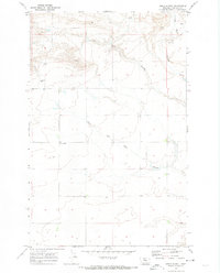
1970 Map of Apple School
USGS Topo · Published 1974About this map
The rolling plains of Chouteau County are defined by the winding erosional paths of the Dry Fork Coulee and West Dry Fork Coulee. This landscape of high prairie and deep draws is centered on the site of the Apple School, a localized landmark for the surrounding rural community. The map reveals the sparse nature of human development in this region during the late 1960s, where structures are few and far between. Visible infrastructure is limited to essential agricultural and industrial markers, including a Storage Bin to the west and a Gravel Pit near the head of Chimney Rock Coulee. The topography illustrates the complex drainage patterns that feed into these coulees, shaping the land for dryland farming and ranching in north-central Montana.
Find a feature on this map
7 named features on this map. Tap any name to fly to it.
Don’t see what you’re looking for? This feature index may not catch every label — zoom into the map to look around manually.
Map Details
Editions of this 1970 Apple School Map
This is the sole edition of this map. No revisions or reprints were ever made.
Other maps of this area

1886 · Great Falls
USGS Topo · 1:250,000

1890 · Fort Benton
USGS Topo · 1:250,000

1892 · Fort Benton
USGS Topo · 1:250,000

1897 · Fort Benton
USGS Topo · 1:250,000

1950 · Dent Bridge
USGS Topo · 1:62,500

1953 · Carter
USGS Topo · 1:24,000

1953 · Tunis
USGS Topo · 1:24,000

1954 · Great Falls
USGS Topo · 1:250,000

1954 · Shelby
USGS Topo · 1:250,000

1957 · Great Falls
USGS Topo · 1:250,000