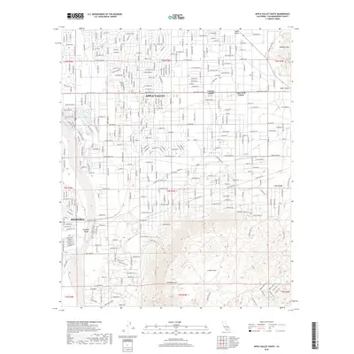
2018 Map of Apple Valley South
USGS Topo · Published 2018About this map
Apple Valley and Hesperia anchor this 2018 survey of the High Desert's transition from suburban development to rugged mountain terrain. The grid of residential streets in the north, featuring named routes like Powhatan Rd and Nisqually Rd, quickly gives way to the open spaces of the Antelope Valley and the rising elevations of the Ord Mountains. The Mojave River carves through the landscape near Jess Lakes, serving as a primary geographical corridor alongside smaller communities such as Lone Wolf Colony and Cotners Corner.
Find a feature on this map
191 named features on this map. Tap any name to fly to it.
Don’t see what you’re looking for? This feature index may not catch every label — zoom into the map to look around manually.
Map Details
Editions of this 2018 Apple Valley South Map
This is the sole edition of this map. No revisions or reprints were ever made.
Other maps of this area

1901 · Southern California Sheet No. 1
USGS Topo · 1:250,000

1902 · Deep Creek
USGS Topo · 1:62,500

1902 · Hesperia
USGS Topo · 1:62,500

1904 · Southern California Sheet No. 1
USGS Topo · 1:250,000

1932 · Barstow
USGS Topo · 1:125,000

1934 · Barstow
USGS Topo · 1:125,000

1942 · Hesperia
USGS Topo · 1:62,500

1953 · San Bernardino
USGS Topo · 1:250,000

1956 · San Bernardino
USGS Topo · 1:250,000
1956 · Hesperia
USGS Topo · 1:24,000