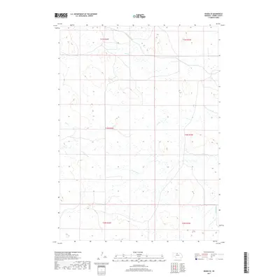
2017 Map of Arabia SE
USGS Topo · Published 2017About this map
Ainsworth Canal cuts across the northern landscape of Cherry County in this 2017 study, illustrating the critical role of water management in Nebraska's sandhills region. The terrain is defined by a complex network of intermittent drainage and wetland pockets, characteristic of the expansive ranching lands south of the Niobrara River. Watercourses such as Rush Cr and Dry Cr feed into the larger hydrologic system, while the N Fork Plum Cr and S Fork Plum Cr wind through the southern sections. This survey provides a precise view of the rural township and range divisions, including t30n r26w and t29n r25w, showing how the land was partitioned for agricultural and grazing use in the early 21st century. The sparse infrastructure, limited to basic section roads, emphasizes the open, unpopulated nature of this prairie environment.
Find a feature on this map
11 named features on this map. Tap any name to fly to it.
Don’t see what you’re looking for? This feature index may not catch every label — zoom into the map to look around manually.
Map Details
Editions of this 2017 Arabia SE Map
This is the sole edition of this map. No revisions or reprints were ever made.
Other maps of this area

1949 · Long Lake
USGS Topo · 1:62,500

1950 · Wood Lake
USGS Topo · 1:62,500

1950 · Arabia
USGS Topo · 1:62,500

1951 · Long Lake
USGS Topo · 1:62,500

1951 · Moon Lake
USGS Topo · 1:62,500

1957 · Valentine
USGS Topo · 1:250,000

1959 · Valentine
USGS Topo · 1:250,000

1985 · Long Lake
USGS Topo · 1:24,000

1985 · Wilson Valley
USGS Topo · 1:24,000
1985 · Brush Creek
USGS Topo · 1:24,000