
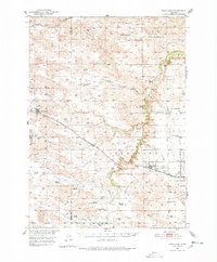
1950 Map of Wood Lake
USGS Topo · Published 1952About this map
Sandhills ranching culture and rail-tied settlements define this mid-century portrait of the Cherry Co Brown Co border. The Chicago and North Western railroad forms the spine of activity, anchoring the towns of Wood Lake and Johnstown, where the Woodlawn Cem sits just east of the village. The landscape is a network of sprawling family operations including the McNamara Ranch, Shepard Ranch, and Anderson Ranch, which are connected by unimproved roads and organized around water sources like Plum Creek and the Snake River.
Find a feature on this map
56 named features on this map. Tap any name to fly to it.
Don’t see what you’re looking for? This feature index may not catch every label — zoom into the map to look around manually.
Map Details
Editions of this 1950 Wood Lake Map
2 editions found
Other maps of this area

1949 · Long Lake
USGS Topo · 1:62,500

1950 · Norden
USGS Topo · 1:62,500

1950 · Huddle Table
USGS Topo · 1:24,000

1950 · Sparks
USGS Topo · 1:62,500

1950 · Arabia
USGS Topo · 1:62,500

1951 · Long Lake
USGS Topo · 1:62,500

1951 · Moon Lake
USGS Topo · 1:62,500

1952 · Norden
USGS Topo · 1:62,500

1954 · Ainsworth NW
USGS Topo · 1:24,000

1954 · Ainsworth SW
USGS Topo · 1:24,000