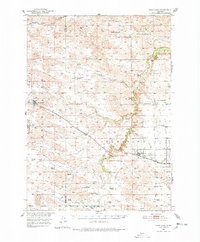
1950 Map of Wood Lake
USGS Topo · Published 1978About this map
Wood Lake and Johnstown anchor this mid-century look at the Nebraska Sandhills, where the Chicago and North Western railway runs parallel to Plum Creek. The landscape is defined by its extensive ranching heritage, with large landholdings such as Shepard Ranch, Burrows Ranch, and McNamara Ranch sprawling across the terrain. This survey reflects the rural educational system of the era, noting numerous district schoolhouses including School No 38, School No 32, and the already Porter Valley Sch (Abandoned). Local genealogists will find value in the specific placement of the Woodlawn Cem and East Woodlawn Cem near the primary settlements. The survey captures the hydraulic network of the region, from Little Minnie Creek to the North Fork Fairfield Creek, during a period of agricultural development within the Missouri River Basin.
Find a feature on this map
53 named features on this map. Tap any name to fly to it.
Don’t see what you’re looking for? This feature index may not catch every label — zoom into the map to look around manually.
Map Details
Editions of this 1950 Wood Lake Map
2 editions found
Other maps of this area

1949 · Long Lake
USGS Topo · 1:62,500

1950 · Norden
USGS Topo · 1:62,500

1950 · Huddle Table
USGS Topo · 1:24,000

1950 · Sparks
USGS Topo · 1:62,500

1950 · Wood Lake
USGS Topo · 1:62,500

1950 · Arabia
USGS Topo · 1:62,500

1951 · Long Lake
USGS Topo · 1:62,500

1951 · Moon Lake
USGS Topo · 1:62,500

1952 · Norden
USGS Topo · 1:62,500

1954 · Ainsworth NW
USGS Topo · 1:24,000